Monday, August 12, 2013
Wednesday, January 2, 2013
Sunday, June 10, 2012
All WEATHER INC.'s Weather station
This is located in Topcular ( Turkish ).
At moment I installed other 3 weather stations. I still have to install 11 additional weather stations.

At moment I installed other 3 weather stations. I still have to install 11 additional weather stations.
Wednesday, June 6, 2012

Tuesday, May 29, 2012
Radar PSR,SSR,COM and Weather Radar
Radar ( RAdio Detection And Ranging) is an object-detection system which uses radio waves to determine the range, altitude, direction, or speed of objects. It can be used to detect aircraft, ships, spacecraft,guided missiles, motor vehicles, weather formations, and terrain. The radar dish or antenna transmits pulses of radio waves or microwaves which bounce off any object in their path. The object returns a tiny part of the wave's energy to a dish or antenna which is usually located at the same site as the transmitter. Radar is used on airport as aircraft anticollision systems and flight control system.
There are three type of radar used for flight control:
- PSR (Primary Surveillance Radar)
- SSR (Secondary Surveillance Radar)
- COM (PSR and SSR)
Primary Radar
Electromagnetic waves reflect (scatter) from any large change in the dielectric constant ordiamagnetic constants. This means that a solid object in air or a vacuum, or other significant change in atomic density between the object and what is surrounding it, will usually scatter radar (radio) waves.
PSR recieve the following data:
- Aircraft range
- Aircraft Azimuth
The average coverage of PSR is 100 nautical miles .

Secondary Radar
Secondary surveillance radar (SSR) is a radar system used in air traffic control (ATC), that not only detects and measures the position of aircraft i.e. range and bearing, but also requests additional information from the aircraft itself such as its identity and altitude. Unlike primary radar systems that measure only the range and bearing of targets by detecting reflected radio signals, SSR relies on targets equipped with a radar transponder, that replies to each interrogation signal by transmitting a response containing encoded data. SSR is based on the military identification friend or foe (IFF) technology.
The average coverage of PSR is 220 nautical miles .

Radar COM
This include Radar PSR and SRS.

Weather Radar
Weather radar, also called weather surveillance radar (WSR) and Doppler weather radar, is a type of radar used to locate precipitation, calculate its motion, and estimate its type (rain, snow, hail, etc.). Modern weather radars are mostly pulse-Doppler radars, capable of detecting the motion of rain droplets in addition to the intensity of the precipitation. Both types of data can be analyzed to determine the structure of storms and their potential to cause severe weather.
Weather radars send directional pulses of microwave radiation, on the order of a microsecond long, using a cavity magnetron or klystron tube connected by a waveguide to a parabolic antenna. The wavelengths of 1 to 10 cm (4 in) are approximately ten times the diameter of the droplets or ice particles of interest, because Rayleigh scattering occurs at these frequencies.
Between each pulse, the radar station serves as a receiver and listens for return signals from particles in the air. The duration of the "listen" cycle is on the order of a millisecond, which is a thousand times longer than the pulse duration. The length of this phase is determined by the need for the microwave radiation (which travels at the speed of light) to propagate from the detector, to the weather target, and back again, a distance which could be several hundred kilometers. The horizontal distance from station to target is calculated simply from the amount of time that lapses from the initiation of the pulse to the detection of the return signal. (The time is converted into distance by multiplying by the speed of light in air) :
(c = speed of light = 299,792.458 km/s, n = refractive index of air ~= 1.0003).

The most frequent use of the radar is located at airports to supportthe air traffic control and safety as well as in meteorological research for studying violent weather phenomena, or in territorial management in the prevention of extreme weather events such as floods, or to monitor the trend of events such as tornadoes or hurricanes.

Thursday, May 24, 2012


Sunday, May 20, 2012
Filed Flight Plan
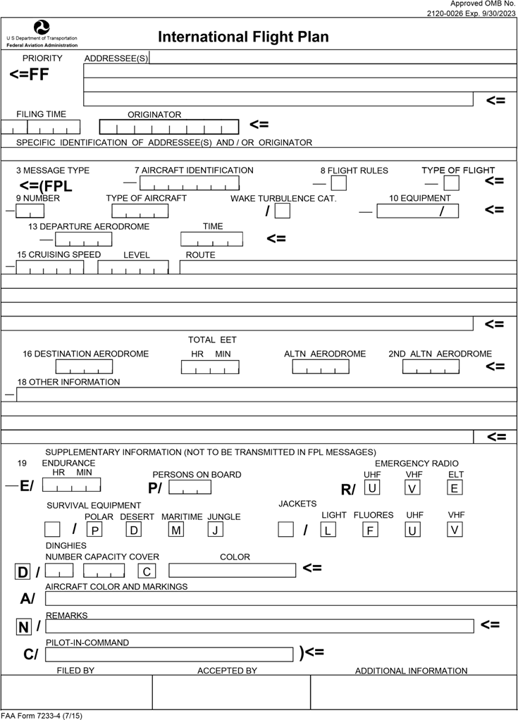
The filed 7 is AIRCRAFT IDENTIFICATION that can be :
- Call Sign
- The ICAO code of company ( e.g. AZA = Alitalia ) and the number of fliglt
The field 8 is FLIGHT RULES and TYPE OF FLIGHT that contain as follow:
- FLIGHT RULES
- <'I'> if is a IFR flight
- <'V'> if is a VFR flight
- <'Y'> if the flight start in IFR and terminates in VFR
- <'Z'> if the flight start in VFR and terminates in IFR
- TYPE of FLIGHT
- <'S'> scheduled Flight
- <'N'> unscheduled flight
- <'G'> General Aviation
- <'M'> military
- <'X'> other
The filed 9 is Number and it is composed by:
Here you enter the number of aircraft if more than 1 (in case of flighttraining)
Type of aircraft (2 to 4 characters)
Here you enter the ICAO code of the aircraft will be using, such asthe B738 Boeing 737-800, B463 for the British Aerospace BAe-146-300 EUFI for the Eurofighter, etc..

Wake Turbulence Category (only one character)
The filed 10 is EQUIPMENT :
In the first part of this box should be added the letters correspondingto the aircraft's communications, navigation and aids for approachon board and working.
Other abbreviations that can be used are :
Here you enter the number of aircraft if more than 1 (in case of flighttraining)
Type of aircraft (2 to 4 characters)
Here you enter the ICAO code of the aircraft will be using, such asthe B738 Boeing 737-800, B463 for the British Aerospace BAe-146-300 EUFI for the Eurofighter, etc..

You can find all codes about aircraft here
- The letter L for "light" that indicates aircraft with a maximum take off weight (MTOW) up to 7,000 kg (15,500 lbs)
- The letter M for "Medium" indicates that aircraft with a maximum takeoff weight (MTOW) exceeding 7,000 kg up to 136,000 kg(300,000 lbs)
- The letter H for "Heavy" indicates that aircraft with a maximum takeoff weight (MTOW) of more than 136,000 kg
The filed 10 is EQUIPMENT :
In the first part of this box should be added the letters correspondingto the aircraft's communications, navigation and aids for approachon board and working.
- The letter N if not present any apparatus or equipment present are unusable
- The letter S for equipment COM / NAV Standard (VHF RTF, ADF,VOR and ILS)
- The letter D for DME (Distance Measuring Equipment)
Other abbreviations that can be used are :
- C LORAN C (Long Range Air Navigation system “B”)
- F ADF (Già incluso in S)
- G GNSS (Global Navigation Satellite System)
- H HF RTF (High Frequency Radiotelephone)
- I INS (Inertial navigation)
- J Data link (in Item 18 specify equipment by DAT/ and one or more letters)
- K MLS (Microwave Landing System)
- L ILS
- M Omega
- O VOR
- R RNP (Area Navigation)
- T TACAN (UHF Tactical Air Navigation Aid)
- U UHF RTF (Ultra-High Frequency Radiotelephone)
- V VHF RTF (Very-High Frequency Radiotelephone)
- W RVSM (Reduced Vertical Separation Minimum)
- X MNPS (Minimum Navigation Performance Specifications)
- Y 8.33 kHz (channel spacing radio equipment)
The filed 13 i Departure Aerodrome
In this filed you see the Aerodrome's ICAO CODE such as:
- LIRF = Rome Fiumicino Airport
- LIML = Milan Linate Airport
- KMIA = Miami International Airport
The filed 15 is composed by :
- Cruising speed
- Level
- Route
Cruising Speed:
In this filed you can find the cruising speed to maintain during the flight with a letter that is the unit that can be :
- K = Km/h
- N = Knots
- M = Mach
It's the flight altitude.
Route:
It's composed by the SID (Standard Instrument Departure), Transition segment to enroute, Airway and all change that aircraft will make.
The filed 16 is composed by:
- Destination aerodrome (airport icao code )
- Total EET (Estimated Elapsed Time) ; it's composed by hours and minute ( example 0230 = 2 hours and 30 minutes)
- Altn aerodrome ( Alternative aerodrome ) ; it's composed by the icao code of Alternative airport
The filed 16 is Other information :
In this filed you can find all information that could be useful for the air traffic control services as follow:
- DOF/
- EET/
- OPR/
- RALT/
- REG/
- SEL/
- STS/
The last filed is Other Information
In this filed you can see as follow:
- Endurance ( HHMM for example 0320)
- Person on board
- Pilot in command (Name and Surname)
- Aircraft color and markings (MTL)

Hope that this post has been of interest to you.
Let me know how you think about.
Subscribe to:
Posts (Atom)